A conceptual framework for your first visit to Xinjiang.
Fresh from a trip to Xishuangbanna, I could not wait to research my next adventure: Xinjiang.
The furthest west I had previously been was an earlier trip to Dunhuang. I had zero baseline concept of traveling in Xinjiang, knowing only that the Tianshan Mountains divide the north from the south. I had only vague impressions of what distinct regions offered or what one could actually experience.
Xinjiang is immense. To filter destinations effectively, I spent two evenings working with AI - collecting, structuring, debating, and validating data - to synthesize this travel cognitive guide. It evaluates the travel experience across all fourteen prefecture-level administrative divisions from the twin lenses of natural scenery and ethnic culture. Combining this with meticulous study of administrative and topographic maps helped me build a clear mental model of Xinjiang tourism.
This is merely a starting point. A framework developed this way is inevitably high-level and may contain minor oversights. The fine details will ultimately be verified and refined by my own eyes and footsteps on the ground.
Part 1: Natural Scenery
Organized across 14 prefecture-level administrative divisions, surveying representative natural landscapes in each region
Overview: The Geographic Logic of Xinjiang
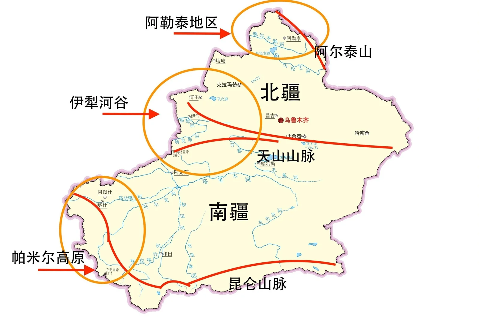
Xinjiang’s geography can be summarized in one classic phrase: Three Mountains Enclosing Two Basins.
- Altay Mountains - Northern grasslands, taiga forests, and alpine lakes
- Junggar Basin - Northern Gobi, gravel deserts, and oasis belts
- Tianshan Mountains - Meadow steppes, snow-capped peaks, and river canyons (the natural divide between North and South)
- Tarim Basin - Sand dunes, gravel wastes, river oases, and desert poplars (Populus euphratica)
- Kunlun Mountains + Pamir Plateau - Ultra-high massifs, glaciers, and alpine plateau lakes
Northern Xinjiang Landscape Keywords: Grasslands, lakes, alpine forests, snow peaks - humid, lush, and scenic.
Southern Xinjiang Landscape Keywords: Sand deserts, Gobi wastes, sandstone canyons, desert poplars - vast, desolate, and rugged.
Eastern Xinjiang Landscape Keywords: Flaming Mountains, Yardang landforms, extreme basin heat - extreme and singular.
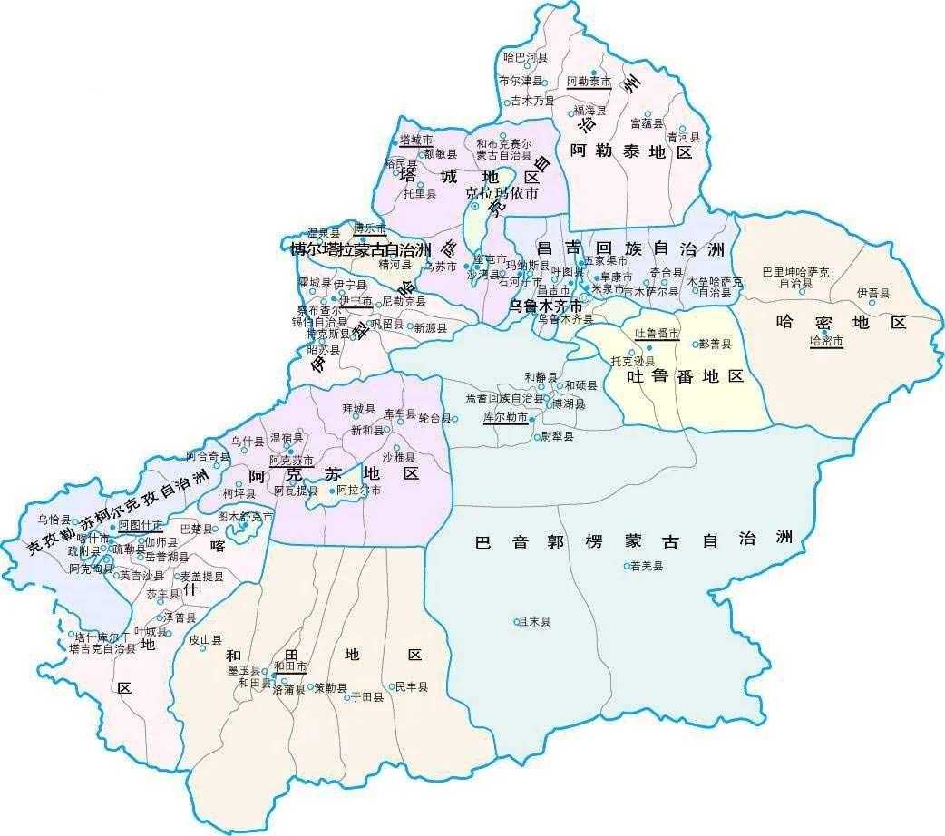
Northern Xinjiang (7 Prefectures & Cities)
1. Ili Kazakh Autonomous Prefecture (Direct Admin Area) - The Jiangnan Beyond the Great Wall
The Ili River Valley forms a funnel-shaped opening facing westward into the Tianshan range, catching moist Atlantic air currents. It receives the highest rainfall and supports the densest vegetation in Xinjiang, celebrated as the “Wet Island of Central Asia.”
| Landscape | Highlights | Distinctive Tags |
|---|---|---|
| Kalajun Grassland | “Three-dimensional steppe,” UNESCO World Natural Heritage site with terraced tiers from valley floors to mountain crests | World Heritage · 3D Steppe |
| Kuerdening | UNESCO World Natural Heritage site preserving the most pristine Schrenk spruce (Picea schrenkiana) forests in Tianshan | World Heritage · Schrenk Spruce |
| Nalati Grassland | Ranked among China’s top six most beautiful grasslands, famous for elevated “sky grasslands” | National 5A · Sky Grassland |
| Tangbula Grassland | “Hundred-Mile Natural Gallery” featuring endless wildflower meadows along Provincial Highway S315 | Natural Gallery · Highway Scenic |
| Sayram Lake | Highest elevation and largest alpine cold-water lake in Xinjiang, “The Atlantic’s Last Tear” (administered by Bortala but bordering Ili) | Alpine Lake · Deep Blue |
| Guozigou Bridge | Spectacular elevated cable-stayed bridge spanning Tianshan gorge, linking Sayram Lake to Ili Valley | Engineering Landmark |
| Zhaosu Grassland | Homeland of Heavenly Horses, vast golden canola flower fields (July), Xiata Ancient Trail entry to Tianshan glaciers | Equine Heritage · Glacier Trail |
| Xiata Ancient Trail | Ancient post road traversing north-south Tianshan toward Muzart Glacier, premier hiking route | Glacier Trekking · Ancient Trail |
| Qiaxi Forest Park | Pristine virgin spruce forests, a tranquil hidden gem in Ili Valley with far fewer tourists than Nalati | Virgin Forest · Off-the-Beaten-Path |
Landscape Summary: Alpine meadows + Schrenk spruce forests + glacial trekking trails + alpine lakes. This is the densest and most visually rich natural landscape corridor in Xinjiang.
2. Altay Prefecture - The Oriental Switzerland
Nestled along the southern slopes of the Altay Mountains at the northernmost tip of Xinjiang. The forest, lake, and snow mountain ecosystem centered around Kanas Lake reaches its aesthetic peak in autumn.
| Landscape | Highlights | Distinctive Tags |
|---|---|---|
| Kanas Lake | Deep alpine lake with color-shifting waters (shifting between blue, green, and milky white across seasons) and legendary “lake monster” folklore | 5A · Photographers Paradise |
| Hemu Village | Tuvan settlement with primitive log cabins, birch forests, and morning mists - one of China’s most picturesque ancient villages | Tuvan Village · Autumn Foliage |
| Baihaba | “The First Village in Northwest China,” situated directly on the border where Kazakhs and Tuvans cohabit | Border Hamlet · Pristine |
| Koktokay | Granite Shenzhong Mountain at the headwaters of the Irtysh River, national geopark | Global Geopark |
| Wucaitan (Rainbow Beach) | Yardang landforms along Irtysh River with vibrant mineral cliffs on northern bank and lush forest on southern bank, stunning at sunset | Yardang · Sunset |
| Ulungur Lake | Second largest freshwater lake in Xinjiang, sandy beaches, famous for winter ice fishing | Great Lake · Ice Fishing |
Landscape Summary: Alpine lakes + virgin taiga forests (birch/larch) + Yardang landforms + frontier cultural hamlets. Mid-September to early October is the optimal travel window.
3. Bortala Mongol Autonomous Prefecture - Gateway to Sayram Lake
| Landscape | Highlights | Distinctive Tags |
|---|---|---|
| Sayram Lake | Highest elevation (2,071m) and largest alpine cold-water lake in Xinjiang, crystal-clear sapphire waters, scenic loop highway | Alpine Lake · 5A |
| Hariturege | Pristine forested gorge at the headwaters of the Bortala River | Forest Canyon · Offbeat |
Bortala is compact; its defining attraction is Sayram Lake. Located at the geographic throat connecting Urumqi to the Ili Valley, virtually all road travelers pass through it.
4. Tacheng Prefecture - Steppes and Frontier Borderlands
| Landscape | Highlights | Distinctive Tags |
|---|---|---|
| Ganjiahu Haloxylon Forest | World’s largest natural nature reserve for ancient Haloxylon ammodendron desert trees | Desert Woodland · Ecological |
| Lujiaowan (Deer Horn Bay) | Alpine pastures in Barluk Mountains, summer highland meadows | Highland Pasture |
| Baketu Port | Active border crossing between China and Kazakhstan with vistas into Kazakh territory | Border Port |
Tacheng’s natural attractions are relatively dispersed with the lowest commercial tourism density in Northern Xinjiang, ideal for off-the-beaten-path expeditions.
5. Changji Hui Autonomous Prefecture - Northern Slopes of Tianshan
| Landscape | Highlights | Distinctive Tags |
|---|---|---|
| Tianshan Tianchi (Heavenly Lake) | Iconic landmark alpine lake situated beneath Mount Bogda | 5A · Iconic Landmark |
| Jiangbulake | Alpine meadows + wheat fields + coniferous forests, vast golden sea of wheat in July and August | Alpine Meadow · Wheat Sea |
| S101 National Defense Highway | Danxia landforms + grasslands + deep canyons along northern Tianshan foothills, termed the “Tianshan Geographic Gallery” | Road Trip · Danxia |
Changji adjoins Urumqi directly. Tianchi is a flagship destination reachable on a half-day excursion. Highway S101 has gained immense popularity for scenic overland driving.
6. Urumqi City - Metropolitan Hub and Tianshan Gateway
| Landscape | Highlights | Distinctive Tags |
|---|---|---|
| Nanshan Scenic Area | Pastures and coniferous forests on northern Tianshan slopes, closest mountain getaway from Urumqi (1.5h drive) | Suburban Pasture |
| Mount Bogda | Highest peak in eastern Tianshan (5,445m), feeding Heavenly Lake on its northern flank | Snow Peak (Distant View) |
Urumqi functions primarily as the central transport hub. Natural landscapes are secondary, with Nanshan serving as a weekend mountain retreat for local residents.
7. Karamay City - Yardang Formations and Gobi Expanses
| Landscape | Highlights | Distinctive Tags |
|---|---|---|
| Urho Ghost City (World Ghost City) | Ranked among China’s top three Yardang formations, wind-eroded natural fortress towers, spectacular at dusk | Yardang Landform · 5A |
| Ailik Lake | Only natural freshwater lake in Karamay, an oasis amidst Gobi wastes | Desert Lake · Offbeat |
Karamay’s natural identity centers on Yardang landforms. Ghost City is an essential scenic stop on the overland driving corridor from Urumqi to Kanas.
Southern Xinjiang (5 Prefectures)
8. Bayingolin Mongol Autonomous Prefecture - The Largest Prefecture in Xinjiang
Covering 470,000 square kilometers (one-fourth of Xinjiang), Bayingolin spans both north and south of the Tianshan range, incorporating both Northern grasslands and Southern desert landscapes.
| Landscape | Highlights | Distinctive Tags |
|---|---|---|
| Bayanbulak Grassland | China’s second largest grassland, vast alpine pasture on southern Tianshan slopes, Swan Lake wetlands, famous Nine Bends Eighteen Turns sunset | Alpine Steppe · Swans · Sunset |
| Bosten Lake | Largest inland freshwater lake in China, extensive reed marshes, immense lake at the desert threshold | Large Freshwater Lake · Reeds |
| Tarim Poplar Forest (Luntai) | World’s largest natural Populus euphratica forest along Tarim River, golden foliage in late October to early November | Poplar Forest · Desert River |
| Lop Nur People Village | Ancient village of Lop Nur descendants along Tarim River blending desert, lake, and poplar groves | Desert Oasis · Cultural |
| Tianshan Stone Forest | Rare high-altitude stone forest formations near Bayanbulak | Alpine Stone Forest · Offbeat |
| Kumtag Desert | Desert reaching directly to urban fringes near Ruoqiang and Qiemo, closest desert to populated cities | Desert Trekking |
Landscape Summary: Extreme diversity - Bayanbulak grasslands in central Tianshan to the north, Bosten Lake in the Yanqi Basin, and Tarim poplar forests bordering the Taklamakan Desert to the south. It is the sole prefecture uniting steppes, great lakes, and vast deserts.
9. Aksu Prefecture - Canyon Kingdom of Southern Tianshan
| Landscape | Highlights | Distinctive Tags |
|---|---|---|
| Tianshan Mysterious Grand Canyon (Keziliya) | Giant reddish-brown sandstone gorge near Kuqa, “The Colorado Canyon of China” | Red Canyon · 5A |
| Wensu Grand Canyon (Tomur Grand Canyon) | Larger and grander than Keziliya, overlaying Danxia, Yardang, and salt-rock geologies | Grand Canyon · Danxia |
| Tomur Peak | Highest peak in Tianshan range (7,443m), principal apex of the entire system | Ultra-High Peak · Mountaineering |
| Tarim River Headwaters | Confluence zone forming China’s longest inland river | River Headwaters |
| Shaya Poplar Forest | Pristine poplar forest along middle Tarim River, second in scale only to Luntai | Poplar Forest |
Landscape Summary: Towering canyon topography is Aksu’s premier asset. Keziliya and Wensu represent Southern Xinjiang’s most dramatic geological landmarks.
10. Kizilsu Kyrgyz Autonomous Prefecture - Gateway to the Pamirs
| Landscape | Highlights | Distinctive Tags |
|---|---|---|
| Oytag Red Mountain | Volcanic formations where reddish cliffs meet descending glaciers, creating a “fire and ice” spectacle | Volcano & Glacier · Offbeat |
| Muji Crater | “The Eye of the Pamirs,” volcanic crater cluster formed 1,500 years ago surrounded by alpine wetlands and glaciers | Volcanic Crater · Alpine Wetland |
| Karakul Lake | Glacial tarn beneath Mount Muztagh Ata at an altitude of 3,600m | Alpine Lake · Peak Reflection |
Kizilsu is compact with modest population, featuring pristine geological landmarks at the gateway to the Pamir Plateau. Oytag and Muji are cherished sanctuaries for landscape photographers.
11. Kashgar Prefecture - The Pamir Plateau and the Edge of the Western Regions
| Landscape | Highlights | Distinctive Tags |
|---|---|---|
| Pamir Plateau | “The Roof of the World,” average elevation 4,000m+, traversed by the Karakoram Highway | High Plateau · Epic Highway |
| Muztagh Ata | “Father of Ice Mountains,” elevation 7,546m, permanently glaciated landmark peak of the Pamirs | Ultra-High Peak · Alpine Landmark |
| Baisha Lake (Chakrak Lake) | Stunning Pamir lake featuring half white sand dunes and half turquoise glacial waters | Alpine Lake · White Sand |
| Karakul Lake | Glacial lake at the foot of Muztagh Ata offering classic peak reflections | Alpine Lake |
| Panlong Ancient Road | Dramatic mountain pass in Kunlun Mountains with over 600 switchbacks, legendary for aerial photography | Highway Landmark |
| Bulungkol Sand Lake | Convergence of towering sand dunes and clear water on the Pamirs | Desert Lake |
| Taxkorgan | High-altitude border town on the Pamir Plateau featuring ancient Stone City ruins and road to Khunjerab Pass into Pakistan | High Plateau Town · Frontier |
Landscape Summary: The Pamir Plateau anchors Kashgar’s natural majesty - ultra-high peaks, glacial lakes, extensive glaciers, and monumental overland highways. This is the highest and most extreme geographic zone in Xinjiang.
12. Hotan Prefecture - Heart of the Taklamakan
| Landscape | Highlights | Distinctive Tags |
|---|---|---|
| Taklamakan Desert | Second largest shifting-sand desert in the world, “The Sea of Death” | Shifting Sand Desert |
| Desert Highway | Cross-desert highway cutting north-south across the Taklamakan (Hotan to Alar), an isolated desert crossing experience | Extreme Highway |
| Niya Ruins | “The Pompeii of the East,” ruins of the ancient Jingjue Kingdom deep within the sands | Ancient Ruins · Expedition |
Hotan’s natural environment is defined by desert wastes. It represents the driest region in Xinjiang, characterized by stark desolate beauty. Crossing the Desert Highway is an iconic milestone in Southern Xinjiang travel.
Eastern Xinjiang (2 Prefecture-Level Cities)
13. Turpan City - Flame and Extreme Heat
| Landscape | Highlights | Distinctive Tags |
|---|---|---|
| Flaming Mountains | Mythological backdrop of Journey to the West, summer surface temperatures exceeding 80°C, crimson sandstone ridges | Extreme Heat · Landmark |
| Grape Valley | Lush oasis canyon nestled within the Flaming Mountains shaded by vast grape trellises | Oasis Canyon · Vineyards |
| Kumtag Desert | Closest desert to urban settlement in the world, walkable from Shanshan county seat | Urban Desert |
| Karez Wells | Underground subterranean irrigation network, celebrated among ancient China’s three monumental civil engineering feats alongside Great Wall and Grand Canal | Water Infrastructure |
| Tuyugou | Oldest preserved Uyghur canyon village, housing Thousand Buddha Caves | Canyon Village · Cultural Heritage |
Turpan possesses China’s lowest elevation point (-154m) and highest summer temperatures. Its natural identity centers on extreme thermal contrast between scorched desert and shaded oases.
14. Hami City - Eastern Tianshan and Gobi Wilderness
| Landscape | Highlights | Distinctive Tags |
|---|---|---|
| Dahaidao (Great Ocean Route) | Xinjiang’s most monumental Yardang formations, hundreds of square kilometers of uninhabited Martian terrain | Yardang · Wilderness No-Mans-Land |
| Barkol Lake | Alpine lake in eastern Tianshan, transitioning between mountain pastures and Gobi wastes | Alpine Lake · Pasture |
| Hami Ghost City | Wubao Ghost City Yardang formations, second in scale only to Urho | Yardang Landform |
| Eastern Tianshan Glaciers | Glaciers on northern Tianshan slopes within Hami territory | Glacial Peaks |
Hami serves as Xinjiang’s eastern gateway. The Dahaidao Yardang wilderness has become a premier destination for overland expedition enthusiasts and photographers.
Cross-Regional Comparisons by Landscape Type
Alpine Lakes
| Lake | Location | Elevation | Key Characteristic |
|---|---|---|---|
| Sayram Lake | Bortala | 2,071m | Most beautiful alpine lake in Xinjiang, deep sapphire blue |
| Kanas Lake | Altay | 1,374m | Color-shifting waters, legendary lake monster lore |
| Tianshan Tianchi | Changji | 1,910m | Iconic national scenic landmark |
| Karakul Lake | Kizilsu / Kashgar | 3,600m | Mirror reflection of Mount Muztagh Ata |
| Bayanbulak Swan Lake | Bayingolin | 2,500m | Wetland swan sanctuary, Nine Bends sunset |
| Baisha Lake | Kashgar | 3,300m | Premier scenic lake of the Pamirs with white sand dunes |
Grasslands
| Steppe | Location | Key Characteristic |
|---|---|---|
| Nalati | Ili | Sky grassland, most developed infrastructure |
| Kalajun | Ili | Three-dimensional steppe, UNESCO World Heritage |
| Bayanbulak | Bayingolin | Swan sanctuary, Nine Bends Eighteen Turns river loops |
| Tangbula | Ili | Hundred-Mile Natural Gallery along highway |
| Zhaosu | Ili | Homeland of Heavenly Horses, July canola blooms |
| Jiangbulake | Changji | Rolling golden wheat sea alongside alpine meadows |
Canyons
| Canyon | Location | Key Characteristic |
|---|---|---|
| Tianshan Mysterious Grand Canyon | Aksu | Crimson sandstone gorge, “The Colorado of China” |
| Wensu Grand Canyon | Aksu | Monumental scale with layered Danxia and Yardang geologies |
| Anjihai Grand Canyon | Tacheng / Shawan | Wild, uncommercialized, vibrant multicolored canyon walls |
Deserts and Yardangs
| Landscape | Location | Key Characteristic |
|---|---|---|
| Taklamakan Desert | Hotan / Bayingolin / Aksu | World’s second largest shifting-sand desert |
| Kumtag Desert | Turpan / Qiemo | Urban-accessible desert |
| Urho Ghost City | Karamay | Premier wind-eroded Yardang fortress landscape |
| Dahaidao | Hami | Vast uninhabited Yardang wilderness with Martian terrain |
Ultra-High Mountain Peaks
| Peak | Location | Elevation | Key Characteristic |
|---|---|---|---|
| Muztagh Ata | Kashgar | 7,546m | “Father of Ice Mountains,” mountaineering landmark |
| Tomur Peak | Aksu | 7,443m | Supreme summit of the Tianshan mountain range |
| Mount Bogda | Changji / Urumqi | 5,445m | Prominent peak feeding Heavenly Lake |
Natural Scenery Travel Planning Recommendations
What to Prioritize in Northern Xinjiang
- Top Choice: Ili Valley (5-7 days): Grasslands + forests + lakes + glaciers. Highest scenic density in Xinjiang.
- Pair with Altay (3-4 days): Kanas + Hemu village autumn colors (optimal seasons differ: Ili peaks June-August; Altay peaks September-October).
- En-Route Stops: Sayram Lake (Bortala), Tianchi (Changji), Ghost City (Karamay).
What to Prioritize in Southern Xinjiang
- Pamir Plateau (2-3 days ex-Kashgar): Muztagh Ata + Baisha Lake + Karakul Lake - epic high-altitude alpine terrain.
- Canyon Route (Aksu): Tianshan Mysterious Grand Canyon + Wensu Grand Canyon - geological wonders.
- Desert & Poplar Forests (Bayingolin / Hotan): Taklamakan Desert + Luntai Tarim Poplar Forest (peak in late October).
What to Prioritize in Eastern Xinjiang
- Turpan (1-2 days): Flaming Mountains + Grape Valley + Karez Wells - oasis culture and extreme thermal topography.
- Hami Dahaidao (1 day): Deep Yardang wilderness, optimal for off-road and expedition photography.
Part 2: Ethnic Culture
Structured based on data from the 2020 Seventh National Population Census
1. Provincial Demographic Composition Overview
The Xinjiang Uyghur Autonomous Region has a resident population of 25.85 million, forming a diverse multi-ethnic society:
| Ethnic Group | Population | Share of Total Population | Share of Minority Population |
|---|---|---|---|
| Uyghur | 11.62 million | 44.96% | 77.85% |
| Han | 10.92 million | 42.24% | - |
| Other Minorities (Kazakh, Hui, Mongol, Kyrgyz, Xibe, etc.) | 3.31 million | 12.80% | 22.15% |
Core Insight: Uyghurs constitute the largest single ethnic group in Xinjiang, but do not exceed half of the total population. Han and Uyghur populations exist in an approximate 1:1 ratio, alongside 12.80% comprising over a dozen other minority groups distributed across autonomous prefectures. One cannot assume absolute Uyghur demographic majority simply from the administrative name of the autonomous region.
2. Ethnic Distribution Across 14 Prefecture-Level Divisions
2.1 Complete Demographic Perspective: Who Holds Local Majorities?
| Division | Region | Han Share | Largest Demographic Group |
|---|---|---|---|
| Urumqi City | North | ~74% | Han |
| Karamay City | North | ~79% | Han |
| Changji Hui Autonomous Prefecture | North | ~74% | Han |
| Bortala Mongol Autonomous Prefecture | North | ~62% | Han |
| Tacheng Prefecture | North | ~61% | Han |
| Bayingolin Mongol Autonomous Prefecture | South | ~59% | Han |
| Altay Prefecture | North | ~40% | Kazakh |
| Ili Prefecture (Direct Area) | North | ~35% | Multi-ethnic pluralistic |
| Aksu Prefecture | South | ~26% | Uyghur |
| Turpan City | East | ~25% | Uyghur |
| Hami City | East | ~71% | Han |
| Kizilsu Kyrgyz Autonomous Prefecture | South | ~11% | Uyghur |
| Kashgar Prefecture | South | ~10% | Uyghur |
| Hotan Prefecture | South | ~7% | Uyghur |
2.2 Minority Composition Breakdown: Largest Minority in Each Division
| Division | Largest Minority Group | Share Within Minority Population |
|---|---|---|
| Kashgar Prefecture | Uyghur | ~97% |
| Hotan Prefecture | Uyghur | ~98% |
| Aksu Prefecture | Uyghur | ~90%+ |
| Kizilsu Prefecture | Uyghur | ~70% (Kyrgyz ~26%) |
| Turpan City | Uyghur | ~85%+ |
| Hami City | Uyghur | ~55%+ (Multi-ethnic pluralistic) |
| Urumqi City | Uyghur | ~45% (Multi-ethnic pluralistic) |
| Karamay City | Uyghur | ~45% (Multi-ethnic pluralistic) |
| Bayingolin Prefecture | Uyghur | ~78% (Mongol ~4%) |
| Altay Prefecture | Kazakh | ~88% |
| Tacheng Prefecture | Kazakh | ~52% |
| Ili Prefecture (Direct) | Kazakh | ~34% (Multi-ethnic pluralistic) |
| Changji Prefecture | Hui | ~40% (Parity with Kazakh ~1:1) |
| Bortala Prefecture | Mongol | ~17% (Followed closely by Uyghur & Kazakh) |
3. Spatial Patterns: The Complete Picture
3.1 Overall Geographic Distribution
Northern Xinjiang
- Urumqi, Karamay, Changji, Bortala, Tacheng - Han majority populations with modern urban infrastructure
- Ili River Valley - Vibrant multi-ethnic mosaic (Kazakh, Han, Uyghur, Hui, Xibe, Mongol)
- Altay - Kazakh majority population (the only division where a non-Han group exceeds 50% in the north)
Eastern Xinjiang
- Hami - Han ~71%, diverse ethnic communities
- Turpan - Uyghur majority population
Southern Xinjiang
- Bayingolin (Korla) - Han ~59%, a distinct demographic outlier in the south
- Aksu - Uyghur majority population, Han ~26%
- Kizilsu - Predominantly Uyghur and Kyrgyz populations (Han ~11%)
- Kashgar - Uyghur ~97%, the cultural heartland of Southern Xinjiang
- Hotan - Uyghur ~93%, the densest concentration of Uyghur population
3.2 Minority Settlement Zones
Primary Uyghur Settlement Areas: Kashgar, Hotan, Aksu, Turpan, Kizilsu
Primary Kazakh Settlement Areas: Altay, Tacheng, Ili
Multi-Ethnic Mosaic Zones (No single minority exceeding 50%): Urumqi, Karamay, Changji (Hui vs Kazakh parity), Bortala (Mongol, Uyghur, Kazakh tripartite balance)
4. Autonomous Prefecture Designations vs Current Demographics
| Autonomous Prefecture | Titular Minority | Titular Minority Share | Largest Minority Group Today |
|---|---|---|---|
| Bayingolin Mongol Autonomous Prefecture | Mongol | ~4% | Uyghur (~32%) |
| Bortala Mongol Autonomous Prefecture | Mongol | ~5.7% | Followed by Uyghur and Kazakh; Mongol ranks 3rd |
| Changji Hui Autonomous Prefecture | Hui | ~10% | Hui slightly leads Kazakh by a narrow margin |
The historical naming of these autonomous prefectures reflects mid-20th century geopolitical considerations and minority settlement policies, presenting interesting contrasts with contemporary demographic shifts.
5. Two Primary Minority Cultural Traditions
Why Focus Primarily on These Two Groups?
While Xinjiang hosts dozens of recognized ethnic groups, Uyghur and Kazakh cultures offer the most prominent cultural touchstones and mature travel infrastructure:
- Mongol: Population in Xinjiang is relatively small with dispersed cultural tourism resources.
- Hui: Widely distributed throughout towns without forming a single concentrated scenic cluster.
- Kyrgyz, Tajik, Xibe: Modest population bases with specialized frontier tourism facilities still evolving.
Uyghur and Kazakh cultures provide clear regional identities paired with well-established visitor facilities.
5.1 Uyghur Culture - Oasis Agrarian Civilization
Cultural Profile
| Dimension | Content |
|---|---|
| Linguistic Family | Turkic language family (shared roots with Kazakh and Turkish) |
| Religious Tradition | Sunni Islam |
| Demographics | 11.62 million across Xinjiang (44.96% of total regional population) |
| Core Heartland | South of Tianshan Mountains, oases encircling the Tarim Basin |
| Economic Baseline | Settled oasis agriculture + vibrant Bazaar market commerce |
Key Cultural Experiences
- Bazaar Culture: Kashgar Grand Bazaar, Hotan Jade Bazaar - Central Asia’s most expansive traditional market systems, condensing commerce, language, handicrafts, and culinary traditions.
- Old Town Architecture: Gaotai Ancient Homes in Kashgar Old City, labyrinthine earthen alleys representing pristine traditional Islamic vernacular architecture.
- Historic Mosques: Id Kah Mosque in Kashgar (among China’s largest historical mosques), Jiaman Mosque in Hotan.
- Oasis Orchard Life: Grape trellises, fig groves, and pomegranate orchards defining traditional courtyard life.
- Cuisine: Polo (lamb pilaf), baked samsa, tandoor roasted lamb, laghman hand-pulled noodles, gangzi jar mutton, yogurt zongzi.
- Craftsmanship: Traditional glazed pottery, Atlas silk weaving, Hotan jade carving, Yengisar knives, and classical Muqam musical suites.
- Festivals: Eid al-Adha (Corban Festival) and Eid al-Fitr (Rozi Festival) - checking festival calendars reveals peak communal celebrations at bazaars and mosques.
Optimal Travel Destinations
| Region | Experience Highlights |
|---|---|
| Kashgar Prefecture | Bazaars + Old City alleys + historic mosques: the intact cultural core of traditional Uyghur heritage |
| Hotan Prefecture | Jade bazaars, traditional silk workshops, authentic rural oasis life |
| Aksu Prefecture | Transition zone between Uyghur heartland and northern trading routes, less commercialized |
| Turpan City | Quintessential oasis farming (Grape Valley, Karez wells), closest proximity to Urumqi |
Top Recommendation: Kashgar. Kashgar is the undisputed cultural capital of Southern Xinjiang and the most vibrantly preserved living Silk Road metropolis in China.
5.2 Kazakh Culture - Steppe Nomadic Civilization
Cultural Profile
| Dimension | Content |
|---|---|
| Linguistic Family | Turkic language family (cognate with Uyghur with distinct phonetic systems) |
| Religious Tradition | Sunni Islam (with pronounced secular and nomadic cultural synthesis) |
| Demographics | Approximately 1.56 million in Xinjiang (~10% of regional minority population) |
| Core Heartland | Western Northern Xinjiang: from Ili River Valley north to the Altay range |
| Economic Baseline | Seasonal transhumance pastoralism, migrating between summer alpine meadows and winter lowlands |
Key Cultural Experiences
- Steppe Pastures: Summer alpine meadows (Nalati, Kalajun, Tangbula) dotted with white felt yurts (kiez uy).
- Seasonal Transhumance: Large-scale pastoral livestock migrations in spring and autumn - a vital cultural spectacle (typically May-June and September-October).
- Yurt Hospitality: Visiting authentic Kazakh pastoral yurts, drinking salted milk tea, tasting baursak pastries, and listening to dombra folk ballads.
- Equine Heritage: Horseback riding, sheep-dragging contests (kokpar), horse racing, and the “Girl Chase” courtship game (Kyz Kuu).
- Musical Traditions: Dombra (two-stringed plucked lute), Aken improvisational poetry duels (designated UNESCO Intangible Cultural Heritage).
- Cuisine: Boiled mutton platter (et), Naryn noodles with shredded meat, kumis (fermented mares milk), baursak fried dough, milk tea.
- Felt Crafts: Traditional felt embroidery showcasing geometric patterns and vivid botanical motifs.
Optimal Travel Destinations
| Region | Experience Highlights |
|---|---|
| Ili Prefecture (Direct) | Nalati, Kalajun, and Tangbula grasslands: most mature Kazakh pastoral tourism infrastructure |
| Altay Prefecture | Highest Kazakh demographic density (52.8%), authentic pastoral life, alongside Tuvan hamlets in Hemu and Kanas |
| Tacheng Prefecture | Baketu border port, remote mountain pastures, uncommercialized and quiet |
Top Recommendation: Ili. While Altay possesses higher Kazakh demographic density, the Ili River Valley combines dramatic mountain grassland landscapes with well-developed pastoral hospitality.
6. Contrast Between the Two Civilizations
| Dimension | Uyghur (Oasis Agrarian) | Kazakh (Steppe Nomadic) |
|---|---|---|
| Geography | South of Tianshan, Tarim Basin oases | North of Tianshan, Ili Valley to Altay pastures |
| Mode of Production | Sedentary farming + Bazaar commerce | Seasonal transhumance, pastoral migration |
| Dwelling Style | Earth-and-timber courtyard residences | Portable white felt yurts (yurt) |
| Core Culinary | Naan bread, polo pilaf, kebabs, fresh fruits | Boiled mutton, naryn noodles, milk tea, kumis |
| Religious Practice | Islamic traditions deeply woven into daily town life | Islamic heritage synthesized with nomadic customs |
| Musical Forms | Classical Twelve Muqam orchestral suites | Dombra lute + Aken improvisational poetry |
| Social Center | The Bazaar (public market) | Steppe gatherings, seasonal festivals |
| Architectural Focus | Mosques, minarets, shaded alleyways | Alpine pastures, yurts, transhumance trails |
| Optimal Travel Season | Year-round (avoiding mid-summer heat) | Summer peak (June to September during green meadows) |
Their primary commonality is their shared homeland within Xinjiang. Aside from that, their languages, pastoral versus oasis economies, culinary staples, music, architectural forms, and rhythms of life present captivating contrasts. Experiencing both dimensions provides a complete perspective on Xinjiang’s rich cultural tapestry.
Part 3: Travel Logistics and Reference Data
1. Hangzhou Direct Flight Connections to Xinjiang
| Destination | Direct Flights | One-Stop Flights (Same Plane) | Operational Notes |
|---|---|---|---|
| Urumqi | Yes | Yes | Highest flight frequency, universal transit gateway |
| Kashgar | Yes | Yes | Southern hub; direct flights bypass Urumqi layovers |
| Altay | Yes | - | Premier gateway for northern autumn foliage |
| Aksu | - | Yes | - |
| Karamay | - | Yes | - |
| Alar | - | Yes | - |
| Yining (Ili) | - | - | Requires transit connection in Urumqi |
| Korla | - | - | - |
| Hotan / Tacheng / Hami / Turpan / Bole | - | - | All require transit via Urumqi |
Route Strategy: Departures from Hangzhou feature three direct airport destinations: Urumqi (universal hub), Kashgar (Southern core), and Altay (Northern autumn route). Other destinations connect via Urumqi or single-stop same-plane itineraries.
2. North vs South Route Comparison
| Dimension | Southern Route (Uyghur Focus) | Northern Route (Kazakh Focus) |
|---|---|---|
| Core Hub Cities | Kashgar, Hotan | Yining, Altay |
| Direct Flights ex-HGH | Kashgar has direct flights | Altay has direct flights; Urumqi offers highest frequency |
| Optimal Travel Window | March-May, Sept-Nov (avoiding mid-summer heat) | June-September (grasslands); Altay foliage in Sept-Oct |
| Travel Rhythm | Leisurely bazaar strolls, historic old towns | Extended road driving, alpine hiking, expansive scale |
| Linguistic Environment | Uyghur prevalent, Mandarin in official venues | Mandarin widely understood across pastoral hubs |
| Dietary Profile | Islamic dining, rich halal mutton, zero pork | Islamic dining, heavy beef, mutton, and fresh dairy |
3. Core Itinerary Recommendations
- If selecting only one region: First-time visitors should choose Northern Xinjiang (Ili). The visual drama of alpine meadows, sapphire lakes, spruce forests, and yurt pastures provides immediate impact with mature infrastructure.
- If time permits (10+ days): Direct flight to Kashgar (South: 3-4 days) → domestic flight to Urumqi → Ili Valley (North: 5-6 days), experiencing both oasis and nomadic civilizations in a single journey.
- Special autumn journey for Kanas: Fly directly to Altay to bypass Urumqi transfers, traveling straight to Hemu and Kanas for peak autumn foliage.
- Southern travel considerations: Hotan and Kashgar rural areas have lower Mandarin penetration; hiring local guides or using translation apps aids deeper engagement. Summer heat in Turpan is intense (approaching 50°C).
4. Commute Distance and Driving Duration Analysis
Xinjiang’s geographic vastness exceeds what travelers from densely populated eastern provinces typically anticipate. Transit time is a critical variable when planning compact itineraries.
The following data reflects road driving queries via the AutoNavi (Gaode) Maps API, grouped by the 14 prefecture-level divisions. Distances and durations represent estimated driving transit from the nearest airport to each attraction under normal road conditions.
1. Urumqi City
Airport: Urumqi Diwopu International Airport
| Attraction | Distance | Driving Duration |
|---|---|---|
| Tianshan Tianchi | 73 km | 56 min |
| Nanshan Scenic Area | 143 km | 1 h 39 min |
2. Changji Hui Autonomous Prefecture ⚠️ Uses Urumqi Airport
Airport: Urumqi Diwopu International Airport
| Attraction | Distance | Driving Duration |
|---|---|---|
| Tianshan Tianchi | 73 km | 56 min |
| Jiangbulake Scenic Area | 236 km | 2 h 38 min |
3. Ili Kazakh Autonomous Prefecture
Airport: Yining Airport
| Attraction | Distance | Driving Duration |
|---|---|---|
| Kalajun Grassland | 123 km | 1 h 47 min |
| Nalati Grassland | 245 km | 3 h 9 min |
| Kuerdening | 152 km | 2 h 11 min |
| Tangbula Grassland | 227 km | 3 h 13 min |
| Qiaxi Forest Park | 179 km | 2 h 57 min |
| Zhaosu Grassland | 183 km | 2 h 39 min |
| Xiata Ancient Trail | 270 km | 4 h 2 min |
4. Altay Prefecture
Airport: Altay Xuedu Airport
| Attraction | Distance | Driving Duration |
|---|---|---|
| Kanas Scenic Area | 229 km | 3 h 12 min |
| Hemu Village | 260 km | 3 h 46 min |
| Baihaba Village | 248 km | 3 h 59 min |
| Wucaitan (Rainbow Beach) | 106 km | 1 h 19 min |
| Ulungur Lake | 106 km | 1 h 44 min |
| Koktokay | 290 km | 3 h 29 min |
5. Tacheng Prefecture
Airport: Tacheng Qianquan Airport
| Attraction | Distance | Driving Duration |
|---|---|---|
| Barluk Mountains | 180 km | 2 h 48 min |
| Ganjiahu Haloxylon Forest | 486 km | 6 h 39 min |
6. Bortala Mongol Autonomous Prefecture
Airport: Bole Alashankou Airport
| Attraction | Distance | Driving Duration |
|---|---|---|
| Sayram Lake | 131 km | 2 h 1 min |
| Hariturege | 61 km | 1 h 1 min |
7. Karamay City
Airport: Karamay Airport
| Attraction | Distance | Driving Duration |
|---|---|---|
| Urho Ghost City | 92 km | 1 h 27 min |
| Ailik Lake | 91 km | 1 h 44 min |
8. Bayingolin Mongol Autonomous Prefecture
Airport: Korla Licheng Airport
| Attraction | Distance | Driving Duration |
|---|---|---|
| Bosten Lake | 76 km | 1 h 8 min |
| Lop Nur People Village | 80 km | 1 h 31 min |
| Luntai Tarim Poplar Forest | 197 km | 2 h 43 min |
| Bayanbulak Grassland | 376 km | 5 h 18 min |
| Kumtag Desert | 661 km | 8 h 32 min |
9. Aksu Prefecture
Airport: Aksu Airport
| Attraction | Distance | Driving Duration |
|---|---|---|
| Wensu Grand Canyon | 49 km | 42 min |
| Tianshan Mysterious Grand Canyon | 305 km | 3 h 33 min |
| Shaya Poplar Forest | 252 km | 3 h 10 min |
10. Kizilsu Kyrgyz Autonomous Prefecture ⚠️ Uses Kashgar Airport
Airport: Kashgar Airport
| Attraction | Distance | Driving Duration |
|---|---|---|
| Oytag Red Mountain | 99 km | 1 h 36 min |
| Muji Crater | 367 km | 4 h 13 min |
11. Kashgar Prefecture
Airport: Kashgar Airport
| Attraction | Distance | Driving Duration |
|---|---|---|
| Baisha Lake (Pamirs) | 158 km | 3 h 1 min |
| Karakul Lake | 190 km | 3 h 26 min |
| Taxkorgan Stone City | 290 km | 4 h 45 min |
| Panlong Ancient Road | 329 km | 5 h 34 min |
12. Hotan Prefecture
Airport: Hotan Airport
| Attraction | Distance | Driving Duration |
|---|---|---|
| Taklamakan Desert Highway | 351 km | 6 h 33 min |
| Niya Ancient Ruins | 371 km | 5 h 11 min |
13. Turpan City
Airport: Turpan Jiaohe Airport
| Attraction | Distance | Driving Duration |
|---|---|---|
| Grape Valley | 15 km | 21 min |
| Karez Folk Culture Park | 13 km | 20 min |
| Flaming Mountains | 39 km | 39 min |
| Tuyugou Canyon Village | 58 km | 57 min |
14. Hami City
Airport: Hami Airport
| Attraction | Distance | Driving Duration |
|---|---|---|
| Hami Ghost City | 38 km | 53 min |
| Dahaidao (Great Ocean Route) | 171 km | 3 h 31 min |
| Barkol Lake | 195 km | 2 h 45 min |